

Ahmednagar Fort
The Ahmednagar Fort is located in the heart of the city of Ahmednagar, Maharashtra. It was the headquarters of theAhmednagar Sultanate. In 1803 it was taken by the British in during the Second Anglo-Maratha War. Later it was used by theBritish Raj as a prison. Currently the fort is under the administration of the Armoured Corps of the Indian Army.
Major features
In 1803 the Ahmednagar Fort was round in appearance, with twenty-four bastions, one large gate, and three small sally ports. It had a glacis, no covered way; a ditch, revetted with stone on both sides, about 18 feet (5.5 m) wide, with 9 feet (2.7 m) water all round, which only reached within 6 or 7 feet (2.1 m) of the top of the scarp; long reeds grew in it all round. The bermwas only about one yard wide. The rampart was of black hewn stone; the parapet of brick in chunam, and both together appeared from the crest of the glacis to be only as high as the pole of a field-officer’s tent. The bastions were all about 4½ feet higher; they were round. One of them mounted eight guns en barbet: it pointed to the eastward; all the rest had jingies, four in each. In 1803 two guns were visible in each bastion, and 200 were said to be ready in the fort to be mounted. A gunshot to the west of the fort was the Pettah of Ahmednagar. The main gate of the fort faced the pettah, and was defended by a small half-circular work, with one traverse and several little towers for men. There is was a wooden bridge over the ditch, which could be taken away in time of war, but it was not a drawbridge. It was reported that an iron trough as large as the bridge, could be placed upon it, or on the supporters of it, and fill with charcoal or other combustibles, to which could be ignited as an enemy approached.
A small river came from the northward, round the west side of the pettah, and passed to the southward of the fort. A nullahalso passed from the northward, between the fort and a town called Bhingar, about a gunshot to the eastward, and joined the river. A potential defensive weakness was a little hill or rising ground close to and east of Bhingar, from which shot from siege guns could reach the fort. Two nills or covered aqueducts came from the hills, a mile or more to the north, passed through and supplied the pettah and the town, and then went into the fort, either under or through the ditch, into which the waste water fell.There were no passages across the ditch from the sally ports, and no part of the aqueducts appeared above the ditch. The nullah mentioned above, had steep banks and passed within 60 yards of the fort; the aqueduct from Bhingar passed under it. There was no bridge or even a prominent crossing point at the nullah and hence no clearly defined route between the fort and the town of Bhingar.There were many small pagodas and mosques round the pettah and the fort, but none exactly between, or between the fort and Bhingar, or nearer to the fort than those towns.
History
The fort was built by Malik Shah Ahmed (after whom the city of Ahmednagar is named) in 1427 CE. He was the first sultan of theNizam Shahi dynasty and he built the fort to defend the city against invaders from neighbouring Idar. Initially it was made of mud but major fortification began in 1559 under Hussain Nizam Shah. It took four years and was finally finished in 1562. In 1596, Chand Bibi the queen regent successfully repulsed the Mughal invasion but when Akbar attacked again in 1600 the fort went to the Mughals.
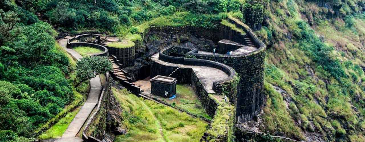
Akola Fort
Akola fort (also called Asadgad or Asagad) along with the Narnala and Akot forts forms the major fortifications of the Akola district, Maharashtra, India.
History
Its earliest form of mud was made by one Akol Singh to protect the village. He saw a hare chasing a dog and considering this to be an auspicious sign, he built an earthen wall here to protect the village. Akola was heavily fortified in 1697 CE during the reign of Aurangzeb by Asad Khan, from whom the fort took its name (Asadgad). In 1803, Arthur Wellesley camped here before proceeding to win the Battle of Argaon in the Second Anglo-Maratha War. The fortress was dismantled by the British Raj in about 1870. It was reported in 1910 in a district gazetteer that the central part of the fort (the hawakhana) was used as a school.
Major features
Akola fort is notable in that it is bereft of any decorative embellishments.
There are several inscriptions on the fort. An inscription on the Dahi handa gate gives its date of construction as 1114 AH (1697 CE), ‘during the reign of emperor Aurangzeb when Nawab Asad Khan was minister.’ Another on the Fateh Buruj bastion has no exact date. It too mentions the same minister but a different emperor (Shah Alam). One on the Eidgahcontains texts and a statement that the building was finished by Khawja Abdul Latif in 1116 AH (1698 CE). On the Agarvesgate an inscription in Marathi reads that Govind Appaji in 1843 CE constructed the fort. The latter statement contradicts all the other inscriptions.
Shri Raj Rajeshwar Mandir
Akola’s oldest Shiva temple is Rajeshwar Mandir. The Shiv temple was built by Chola Empire king Raj Rajeswar.
Folklore
While king Akolsingh was living in the Asadgad Fort, there is a famous story is associated with this payas temple. Every night his queen went to this temple to worship Lord Shiva at midnight. She had deep belief in Lord Shiva. Once king Akolsingh thought that his queen was going out at midnight for a wrong reason, so he followed her with a sword; the queen came to know that King Akolsingh was following her, thinking that she was walking at midnight not for worship but for something illicit. She felt gloomy and guilty and went straight to the Shiva temple and pleaded to the god that her husband the king was thinking wrong about her, and that it was insulting that he was having no faith in her loyalty and her character. So she pleaded “kindly get me into your Pind (ShivaLing)”, and suddenly the Shiva ling broke in two parts and the queen jumped into that ling, and then it was closed. The king understood his mistake and could not forgive himself. Still the Shiva ling in this temple has a little crack which shows and proves the reality of ancient story. This temple is the base aastha of this Akola city. There are 2 bridges: the first one is the dagadi pool (stone bridge) and the other is lokhand pool (iron bridge). This iron bridge was built at the time of British.
Alang Fort
Alang Fort (also Alangad) is a fort in Nashik district, Maharashtra, India. It is one of the three forts, the others being Madangad and Kulang, in the Kalsubai range of the Western Ghats. They are the most difficult to reach forts in Nasik District. A dense forest cover make these treks difficult. These three forts are a little neglected due to very heavy rains in the area and a difficult confusing path to the forts
Fascinating Spots
The top of the fort is a huge plateau. On the fort, there are two caves, a small temple and 11 water cisterns. Remnants of buildings are spread over the fort. Kalasubai, Aundh Fort, Patta and Bitangad are to the east of the fort, Harihar, Trymbakgad and Anjaneri to its north and Harishchandragad, Aajobagad, Khutta (pinnacle), Ratangad and Katrabai to its south.
Ways ToReach
Igatpuri/Kasara-Ghoti-Pimpalnermor-Ambevadi
To reach Alang, go to Kasara or Igatpuri and then Ambevadi by the Igatpuri/Kasara-Ghoti-Pimpalnermor route. There is a bus service from Ghoti to Ambevadi.. Ambevadi is 32 km away from Ghoti. A bus is available at 6 a.m. from Ghoti to Ambevadi. We can easily see Alang, Madan and Kulang from there. From Ambevadi, a way goes to the ridge between Alang and Madan, which may take up to 3 hours. From the ridge, the fort visible on the left is Alang, while the one on the right is Madan.
From there, two ways go towards Alang.
a) One way descends from the ridge. Within 1 hour you can reach the plateau. Keeping Alang to your left, you will reach a cavern after about an hour’s walk. From there, you can go higher by rock climbing. Then you will reach a flat patch. Keep left and proceed towards the pinnacle. After 10 to 15 minutes, you will come at a cave in the fort. Time required to reach here from Ambevadi is approximately 8 to 9 hours.b) Proceed from the ridge and after easy rock climbing, you will come near few steps. After ascending these steps, climb a broken pinnacle of 80 to 90 ft. Only trained climbers should go this way. This way, you can reach the fort after 6 hours.
Ghatghar via Ghoti-Bhandardara
Another way towards fort is from Ghatghar. Go at Ghatghar via Ghoti-Bhandardara. From there, in 2½ hours, one can come to the third cavern. Via Bhandardara from Udadvade : Other way towards fort is via Bhandardara from Udadvade gaon.
Accommodation Facility
Two caves on the fort can accommodate 30-40 people.
Food Facility
You have to carry with your own.
Drinking Water Facility
Ample water is available in reservoirs in all seasons Still, we have to carry sufficient water till we reach at the top.
Time To Reach
7–8 hours from Ambevadi
Balapur Fort
Balapur Fort is a Mughal fortress in fairly good condition situated in the town of Balapur in the Akola district of India. Construction on the fort was started by Mirza Azam Shah, the son of Emperor Aurangzeb and it was completed by Ismaeel Khan, the Nawab of Elichpur in 1757. The chhatri (umbrella-shaped pavilion); a canopy constructed by Mirza Raja Jaisingh, has an area of 25 square feet and a height of 33 feet. Its foundations were heavily damaged in a great flood called the ‘dhvdya pur’ which occurred more than 100 years ago, but after some years the damage was repaired at a cost of Rs 3,000 received from Jaipur.
History
The old Gazetteer states, “People are sufficiently educated to scrawl their names on all parts of the chhatri, and a stone in the middle has been coloured with the ubiquitous sacred red. The frivolous say that visitors to the chhatri must do three thing Firstly, they should note the char bot ki patthar, four-fingers stone, which has been set in near the top of a pillar on the soul. In 1616, Shah Nawaz Khan, the Subedar of Barar was camping at Balapur. the defeated Malik Ambar attacking him near Kirkee by way of Rohinkheda pass. But he could not hold for long and had to retreat to Balapur. Aurangzeb, after ascending the imperial throne at Delhi, appointed Raja Jaisingh as the Governor of the Dakkan. He constructed a very pretty chhatri, umbrella-shaped pavilion, 25 feet square and 33 feet in height at Balapur. Mirza Azam Shah, son of Aurangzeb, is said to have lived here and to have built a mud fort. It may be noted that as per the Treaty of Purandar, the Balapur pargana along with the Avandhe pargana was given in the name of Sambhaji as a Jageer and he was made a commandant of 5,000.
Location
The Balapur fort is situated in Balapur, a large town located at the junction of the rivers Man and Bhains, in west-central India.The old Gazetteer mentions that the town contained a mosque of 1737 in Kasarkhera. It further states, ‘The mosque in Kasarkhera is a fair specimen of later Mughal architecture, but the arches arc too squat to be graceful; a long and somewhat bombastic inscription, exceedingly well executed and well preserved, gives as the date of construction of the mosque the year 1737. The mosque is known as the Raozah Masjid, for it contains the tomb of a local saint Maolvi Masoom Shah.’ The old Gazetteer also states, ‘A fine haveli in the town was built by a local saint, Sayyad Amjad, and an inscription over the principal gateway, a good specimen of Mughal architecture, conveys the information that it was built in 1703.’ Situated on an elevated ground between the two rivers, the fort has very high walls and bastions built of the best brickwork of its time. The fort has three gateways, one within the other. With Balapur hailed as an important military station during the times of the Mughals, the fort too was built keeping in mind the town’s military responsibilities and position. Complex architecture used in the fort ensured its safety, as well as eased the discharge of missiles and other ammunition from within the fort, rendering it one of the most impenetrable forts in the county. During the rains, the Fort gets surrounded by floodwater except at one point. The temple of Bala Devi, from which the town has derived its name, lies just under the Fort, on the southern side.Still in a relatively good condition, the Balapur Fort is now used by the government for offices. A quiet spot, this fort held supreme importance during the time of the Mughals.
Bandra Fort
Castella de Aguada (Portuguese: Fort of the Waterpoint), also known as the Bandra Fort, is a fort located in Bandra, Mumbai. “Castella” is a misspelling for Portuguese “Castelo” (castle). Properly, it should be called Castelo da Aguada, although it seems its Portuguese builders actually called it Forte de Bandorá (or Bandra Fort). It is located at Land’s End in Bandra. It was built by the Portuguese in 1640 as a watchtower overlooking Mahim Bay, the Arabian Sea and the southern island of Mahim.[1] The strategic value of the fort was enhanced in 1661 after the Portuguese ceded the seven islands of Bombay that lay to the immediate south of Bandra to the English. The name indicates its origin as a place where fresh water was available in the form of a fountain (“Aguada”) for Portuguese ships cruising the coasts in the initial period of Portuguese presence. The fort lies over several levels, from sea level to an altitude of 24 metres (79 ft).
History
The Portuguese, who had established a base in the area in 1534 after defeating Bahadur Shah of Gujarat, built several sea forts along the western Indian coastline. Castella de Aguada was one such strategically located fort, overlooking the Mahim Bay to the south, the Arabian Sea to the west, the islands of Worli to the south and the town of Mahim to the south west. The fort also guarded the northern sea route into Mumbai Harbour. This sea route, a large estuary, was later reclaimed from the sea in the nineteenth century. During the Portuguese rule, it was armed with seven cannons and other smaller guns as defence. A freshwater spring in the vicinity supplied potable water to passing ships, thus lending the fort its name. After the decline of the Portuguese in the early 18th century, the Marathas became the largest threat to British possessions. Sensing an impending Portuguese defeat, the British partially demolished the fort as a precautionary measure. The demolition would obviate the possibility of the fort being captured by the Marathas, with the possibility of it being used as a forward military base to attack British Bombay. In 1739 the island was invaded by the Marathas; it was ruled by them until 1774 when the British gained possession of the area during the First Anglo-Maratha War. In 1830, the British donated large parts of Salsette Island, including Land’s End (Click to view the Photosphere), to Byramjee Jeejeebhoy, a Parsi philanthropist. Jeejeeboy then established his residence on the hill where the fort is located, and the cape was renamed Byramjee Jeejeebhoy Point.
Conservation
In 2003, a conservation program was started by Bandra Band Stand Residents’ Trust to save the fort. It was spearheaded by a local Member of Parliament (MP), Shabana Azmi, who funded part of the effort from her allotted funds. The brick arch of one of the gateways on the verge of collapse, and the foundation masonry of the fort wall that was in danger of tidal erosion were repaired. The nearby Taj Land’s End hotel is responsible for maintenance of the fort, having inherited it from the previous owners. The fort is owned by the Archaeological Survey of India (ASI). Included in the fort makeover are the preservation of the natural rock formations, providing pathways, and the creation of an amphitheatre. The architect for the makeover was P.K. Das, who had earlier redesigned the Carter Road area.
Bassein Fort
Vasai or Bassein Fort is a large fort in Vasai village, in the Vasai taluka (county) of the District of Palghar, Konkan Division, MaharashtraState, Republic of India. The name “Bassein” is the English version of the Portuguese “Baçaim” (with the “ç” spoken as “s” and with the “m” silent), itself a version of an apparently native name that may have a connection to the Vasa Konkani tribals of the North Konkan region, extending from Mumbai into “South Gujarat.” The Marathi name of the place is Vasai.The complete form of the Portuguese name is “Fortaleza de São Sebastião de Baçaim” or the Fort of St. Sebastian of Vasai. The Vasai fort is a monument of national importance and is protected by the Archaeological Survey of India. The fort and the village are accessible most easily through the Vasai Road Railway Station, which itself is in Manikpur-Navghar, a part of the newly raised City of Vasai-Virar (See “Vasai-Virar Municipal Corporation”), and lies to the immediate north of the cities of Mumbai and Mira Road-Bhayander. The “Vasai Road” Railway Station is on the Western Railway line (formerly the Bombay, Baroda & Central India Railways) in the direction of Virar Railway Station
History
Portuguese mariners exploring the north Konkan Coast, discovered the Arab Sultanate of Khambat or Cambay, building or renovating or expanding the fort in the early 1400s and attacked it in a failed effort to seize it. Later, after more systematic efforts, the Sultanate of Cambay ceded the fort to Portugal by the Treaty of Saint Matthew signed on the Portuguese brig Sao Matteus anchored in the Bhayander Creek or Vasai Harbor.Under Portugal, the fort was the Northern Court or “Corte da Norte,” second only to the City of Goa, functioning as the headquarters of the Captain of the North. For 150 odd years, the presence of the Portuguese made the surrounding area a vibrant and opulent city. As such it was the capital of Portuguese possessions on the coast north of Goa, over places such as Chaul-Revdanda, Karanja Island, the Bombay Archipelago, Bandra Island, Juhu Island, Salsette Island including the City of Thane, Dharavi Island, the Vasai archipelago itself, Daman, Diu, and other Portuguese holdings extending up the coasts to Pakistan, Oman, the UAE, Iran, and other parts of the Persian Gulf.The ethnic community locally known in the Bombay region as the “East Indians” (sic) were called “Norteiro” (Northernmen) after the Court of the North functioning out of the fort. In the 18th century, the fort was taken over by the Maratha army under Peshwa Baji Rao’s brother Chimaji Appa, and fell in 1739 after a three-year-long campaign. (See-Battle of Vasai) The British shortly attacked and took over the territory from the Marathas as the price for supporting one faction of the Marathas against another.
Present
The ramparts overlook what is alternatively called the Vasai Creek and the Bhayander Creek and are almost complete, though overgrown by vegetation. Several watch-towers still stand, with safe staircases leading up. The Portuguese buildings inside the fort are in ruins, although there are enough standing walls to give a good idea of the floor plans of these structures. Some have well-preserved façades. In particular, many of the arches have weathered the years remarkably well. They are usually decorated with carved stones, some weathered beyond recognition, others still displaying sharp chisel marks.\Three chapels inside the fort are still recognisable. They have façades typical of 17th-century Portuguese churches. The southernmost of these has a well preserved barrel-vaulted ceiling. Besides all the structures one should not miss observing the nature that has taken over much of the fort. It is a great place to observe butterflies, birds, plants and reptiles. The Archaeological Survey of India has started restoration work of the fort, although the quality of the work has been severely criticized by “conservation activists”. It is said that the fort has a bad reputation for illegal activities and that during the week days its not advisable for tourists or women to visit it.
Accessibility
One needs to take a Western Railways train bound to Virar from Churchgate and get off at Vasai Road. If someone is coming from the Central Railway or Central Railway Harbour Line then they have to switch to the Western Railway line at either Dadar, Bandra or Andheri. Another railway line connects the Central and the Western Railways lines from Vasai Road Railway Station to Diva, a stop just beyond Thane city on the Central Railway line, and long-distance passenger trains travelling this route also carry commuters between the two lines. A new railway station named Kopar has started which is between Diva and Dombivli. Passengers travelling from Thane or Kalyan can alight at Kopar and go top by staircase and at Platform No.3 they can catch the Diva to Vasai train. Vasai Road station is only one hour by train from Kopar station. Currently there are 5 trains daily which goes to Vasai Road from Dombivli, Diva and Panvel and 5 trains from Vasai Road to Diva and Panvel. There is a State Road Transport Bus Terminus & Station adjacent and to the immediate west of the Vasai Road Railway Station in Manickpur-Navghar. The destination for buses going to the Vasai fort is “Killa Bunder” or “Fort Jetty/Quay.” There are buses every half hour. Ticket costs you Rs. 7.00 and you can get off at the last stop and walk around. Auto-Rickshaws are also available which can be hired from the western entrance to the Railway station but cost more per head and are unsafe in that they are usually congested. Auto Rickshaws are also available which can be hired from the main road outside the station but it would cost you around Rs.20.00 per head.
Belapur Fort
Belapur Fort is a fort near the township of Belapur in Navi Mumbai (New Bombay), Maharashtra, India. The fort was built by theSiddis of Janjira. It was later conquered by the Portuguese, and then Marathas. In the early 19th century, the fort was captured by the British. After the British gained supremacy in the region, with the expansion of the Bombay Presidency, the strategic importance of the fort declined, and it fell into disuse.
History
Built in 1560–1570 by the Siddis, after they wrested control of the area from the Portuguese, it is located atop a hillock, near the mouth of the Panvel Creek. In 1682, the fort was recaptured by the Portuguese, who had managed to annex the regions controlled by the Siddis, near Belapur (at that time known as Shabaz). In 1733, the Marathas, led by Chimnaji Appa, wrested control of the fort from the Portuguese. He had made a vow that if it were to be successfully recaptured from the Portuguese, he would place a garland of beli leaves in a nearby Amruthaishwar temple, and after the victory the fort was christened as Belapur Fort. The Marathas ruled the area until 23 June 1817, when it was captured by Captain Charles Gray of the British East India Company. The British partially destroyed the fort under their policy of razing any Maratha stronghold in the area During its active days, the fort stationed four companies each of 180 men, and 14 guns ranging from 4–12 pounds (2–5 kg) in weight. An underground tunnel is also supposed to exist, which many locals believe connects it to Gharapuri Island, the site of theElephanta Caves.
Restoration
The fort comes under the jurisdiction of City and Industrial Development Corporation (CIDCO). It lies in a dilapidated state. Plans are underway to renovate the fort which is in danger of being lost to encroachments. Residents have used the Right to Information Act to save the fort from dumping and debris. A pond in the vicinity that supplies water to the area is also in danger of being choked.
Bhimgad Fort
Bhimgad Fort are historical ruins located within the Bhimgad Wildlife Sanctuary, on a detached spur of the Western Ghats, in Khanapur Taluk of Belgaum District near JambotiVillage, Karnataka state, India. It is located in the heart of the Mhadei river watershed. It was built and occupied by Shivaji Maharaj in the mid 17th century during his conquest ofSouth India to defend from the Portuguese colonial troops who controlled Goa at that time.
Location
The fort sits on top of a 300 ft (91 m) rock outcropping at the crest of the escarpment overlooking the Mhadei Wildlife Sanctuary and rising 1,800 ft (550 m) near vertically above the plains to the west. The defenses were almost entirely natural, requiring little additional construction.
History
Near the end of 1676, Shivaji besieged Belgaum and Vayem Rayim in current day northern Karnataka. From here he launched a wave of conquests in southern India with a massive force of 30,000 cavalry and 20,000 infantry.[2] Bhimgad was one of the forts that Shivagi still held when he died in 1680. In 1719, the fort was included with the 16 districts given to a grandson of Shivagi, Chattrapati Shahu, at the beginning of his own rule. About 1787, the fort was overtaken by theNesagari chief but it was soon retaken. In 1820 it was observed by the British and in 1844 it was occupied by them to guard against insurgents who threatened Belgaum.
Description
There is one narrow stone-cut trail leading up to the fort. The ruins are 1,380 ft (420 m) long from north to south and 825 ft (251 m) broad from east to west. The fort has only one gateway and the walls are still mostly intact. The inside is overgrown with brush and there is one fresh-water spring on the west side and a small reservoir in the north, both of which are dry in the two hottest months of the year. The fort had an eight-pound gun and a three-pound gun plus a wall musket. Bhimgad was one of the forts that Shivagi still held when he died in 1680.
Chakan Fort
Sangram Durga is a land fort situated at Chakan, Pune, India. It is famous for its defense by Firangoji Narsala a renownedMaratha warrior and military leader in the army of Shivaji, a Maharaja of the Maratha Empire, against a Mughal army led byShaista Khan in 1660 .Firangoji was a Killedar(commander) of this fort in Chakan (Pune). When Shaista Khan invaded Pune with a lakh of soldiers, he selected Sangram Durga as the first target. He attacked the fort with 10,000 soldiers. Firangoji Narsala was prepared for this attack, despite only having 200 soldiers at his disposal. Just before this attack Shivaji had asked his commander to leave the fort, however Firangoji decided not to abandon the fort and instead started a fierce guerrilla war against the Mughals and defended the fort for almost two months.The Mughals tried another way of taking the fort. They dug a tunnel up to the fort; which was a challenge because of the water around it. They filled this tunnel with explosives and blew up the wall of the fort. This was a major setback for Firangoji and his soldiers; 75 soldiers died in this attack. The Mughal army rushed into the fort; fierce fighting ensued and many Maratha soldiers were killed.Shaista Khan was astonished by Firangoji’s bravery, and offered him Mughal Sardari. Firangoji refused to accept it and instead Shaista Khan gave him and his soldiers safe passage. Firangoji came to meet Shivaji and apologised for surrendering the fort. Shivaji, happy with him for having defended the small fort for almost 2 months said “if it took 60 days for Shaista Khan to take a small fort, imagine how many days will be required to capture an entire swarajya (kingdom)”. Shivaji rewarded Firangoji and made him Killedar of the Bhupalgad fort .
Chanderi Fort
Chanderi Fort located at Chanderi in Ashoknagar District of Madhya Pradesh state in India is situated at a distance of 127 km from Shivpuri and 37 km from Lalitpur and about 45 km fromEsagarh and 38 km from Mungoali It is located on a hill southwest of the Betwa River. Chanderi is surrounded by hills, lakes and forests and there are several monuments of the Bundela Rajputs andMalwa sultans. Chanderi finds mention in Mahabharata. Shishupal was the king of Mahabharata period. Chanderi is located strategically on the borders of Malwa and Bundelkhand. History of Chanderi goes back to the 11th century, when it was dominated by the trade routes of Central India and was proximate to the arterial route to the ancient ports of Gujarat as well as to Malwa, Mewar, Central India and the Deccan. Consequently, Chanderi became an important military outpost Chanderi Fort, a vast Mughal fort, dominates the skyline of the lovely old town of Chanderi. The main gate of the fort is known as the “Khooni Darwaza”. Chanderi fort is situated on a hill 71 meter above the town. The fortification walls were constructed mainly by the Muslim rulers of Chanderi. To the southwest of the fort there is a curious gateway called katti-ghatti made through a hill side
History
Chanderi is mentioned by the Persian scholar Alberuni in 1030. Ghiyas ud din Balban captured the city in 1251 for Nasir ud din Mahmud, Sultan of Delhi. Sultan Mahmud I Khilji of Malwa captured the city in 1438 after a siege of several months. In 1520 Rana Sangha of Mewar captured the city, and gave it to Medini Rai, a rebellious minister of Sultan Mahmud II of Malwa. The Mughal Emperor Babur captured the city from Medini Rai, and in 1540 it was captured by Sher Shah Suri, and added to the governorship of Shujaat Khan. The Mughal Emperor Akbar made the city asarkar in the subah of Malwa. The Bundela Rajputs captured the city in 1586, and it was held by Ram Sab, a son of Raja Madhukar of Orchha. In 1680 Devi Singh Bundela was made governor of the city, and Chanderi remained in the hands of his family until it was annexed in 1811 by Jean Baptiste Filose for the Maratha ruler Daulat Rao Sindhia of Gwalior. The city was transferred to the British in 1844. The British lost control of the city during the Revolt of 1857, and the city was recaptured by Sir Hugh Rose on February 14, 1858. Richard Harte Keatinge was awarded the Victoria Cross for leading this assault. The city was transferred back to the Sindhias of Gwalior in 1861, and became part ofIsagarh District of Gwalior state. After India’s independence in 1947, Gwalior became part of the new state of Madhya Bharat, which was merged into Madhya Pradesh on November 1, 1956.
Fort (Mumbai)
Fort Bombay
Fort is a business district in Mumbai, India. The area was the heart of the city during the 18th century. The area gets its name from the defensive fort, Fort George, built by the British East India Company around Bombay Castle. The area extends from the docks in the east, to Azad Maidan in the west; Victoria Terminus in the north to Kala Ghoda in the south. This area is the heart of the financial area of the city. Institutions such as the Bombay Stock Exchange, Reserve Bank of India and Tata Group headquarters are located in this area.
History
The Fort area was declared protected under regulations of the Maharashtra Government Urban Development Department. An advisory committee now oversees the development, repairs and renovations of structures in the precinct.
Ghodbandar Fort
Ghodbunder Fort is a located in Ghodbunder Village, Thane, Maharashtra, India, on the hill just south of the Ulhas River. It was built by the Portuguese, occupied by the Maratha Empire, and became the East India Company’s district headquarters. The place was called as Ghodbunder because in was where the Portuguese used to trade for ghode (horses) with the Arabs. Hence the name Ghodbunder: ghode (horses) & bunder (port).In 1530 the Portuguese came to Thane, and they began fortifying the hill area about 1550, but completion of the fort in its current form was in 1730. The Portuguese name for the fort was Cacabe de Tanna. It was under Portuguese rule until 1737. The Portuguese built a church in the fort that still stands and is now used as a hotel. Two angels engraved on the inside wall of the church still remains. The old church can be seen clearly in the background of the courtyard photo. There are many old maps and texts which mention continual attempts by the Marathas to capture this fort. The Portuguese were able to defend Ghodbunder Fort from these attacks successfully for many years including the attack in 1672 by the forces of Shivaji. However, the Marathas under Chimnaji Appa successfully besieged the fort and took it over from the Portuguese in 1737. Following its capture,Sambhaji ordered the strengthening of the fortifications, initiating the construction of the tower.In 1818, the British occupied the fort and made it the headquarters of the district administration for the East Indian Company, with a district collector stationed in Thane. Currently the fort lies in ruins, but there has been some renovation work started by the Government to preserve it. The fort itself is under the control of the Archaeological Survey of India (ASI).
Jaigadh Fort
Jaigad Fort is a coastal fortification that is located at the tip of a peninsula in Ratnagiri District, in the state of Maharashtra, India. Nestled on a cliff, it overlooks a bay formed where the Shastri river enters the Arabian Sea. It has a commanding view of the bay and the open sea. A jetty port, and a lighthouse is located nearby. Although in ruins, most of the fort’s outer wall and ramparts still stand. A deep moat surrounds the fort side not facing the cliff edge. It is a protected monument
Janjira Fort
Murud-Janjira is the local name for a fort situated on an island just off the coastal village of Murud, in the Raigad district of Maharashtra, India. It was occupied by the Siddis and is famous for being the only fort along India’s Western coast that remained undefeated despite Dutch, Maratha and English East India Company attacks.
Origins of the name
The word Janjira is not native to India, and may have originated after the Arabic word Jazeera, which means an island. Murud was once known in Marathi as Habsan (“of Habshi” or Abyssinian). The name of the fort is a concatenation of the Konkani and Arabic words for Island, “morod” and “jazeera”. The word “morod” is peculiar to Konkani and is absent in Marathi.
Major features
Murud-Janjira Fort is situated on an oval-shaped rock off the Arabian Sea coast near the port town of Murud, 165 km (103 mi) south of Mumbai. Janjira is considered one of the strongest marine forts in India. The fort is approached by sailboats from Rajapuri jetty. The main gate of the fort faces Rajapuri on the shore and can be seen only when one is quite close to it. It has a small postern gate towards the open sea for escape. The fort has 19 rounded bastions, still intact. There are many cannons of native and European make rusting on the bastions. Now in ruins, the fort in its heyday was a full-fledged living fort with all the necessary facilities, e.g., palaces, quarters for officers, mosque, two small 30 feet deep natural fresh water lakes, etc. On the outer wall flanking the main gate, there is a sculpture depicting a tiger-like beast clasping elephants in its claws. There are prominent “ASHOK-CHAKRAS” on all major gates of the fort Janjira. There are images of playing elephants, lions etc. The palace of the Nawabs of Janjira at Murud is still in good shape. The palace was self-sufficient and must have support of the locals. It has secret gates to hide and escape. Its construction is unique and very strong. Originally the fort was a small wooden structure built by a Koli chief in the late 15th century. It was captured by Pir Khan, a general of Nizamshah of Ahmednagar. Later, the fort was strengthened by Malik Ambar, the Abyssinian-origin Siddi regent of Ahmednagar kings. From then onward, Siddis became independent, owing allegiance to Adilshah and the Mughals as dictated by the times.The last surviving prince Roby Philip lives in New York.
History
The fort was originally built in the 15th century on a smaller scale by a local Maratha-Fisherman Chieftain- Ram Patil to protect his people from pirates/ thieves and was known as ” Medhekot”. He was a fearless man with independent bent of mind who was quite popular with the local fishermen. Nizam, the ruler from Ahmadnagar sent one of his Siddi commanders Piram Khan, who came with three ships armed with necessary weapons and soldiers and captured the fort. Piram Khan was succeeded by Burhan Khan, who demolished the original fort and built an impregnable much bigger, 22 acre, stone fort sometime in between 1567 and 1571. The fort was called ‘Jazeere Mahroob Jazeera ‘ which in Arabic means an Island. Siddhi Ambersatak was nominated as Commander of the fort. Despite their repeated attempts, the Portuguese, the British and the Marathas failed to subdue the power of the Siddi’s, who were themselves allied with the Mughal Empire. Major historical figures from Murud-Janjira include men such as Yahya Saleh and Sidi Yaqub. The fort has a tunnel which opens in Rajpuri. The fort was made by a mixture of lead, sand and gul. The Marathas led by Chatrapati Shivaji Maharaj attempted to scale the 12 meters high Granite walls but failed in all his attempts. His son Chatrapati Sambhaji Maharaj even attempted to tunnel his way into the fort but was unsuccessful in all his attempts. In the year 1736, Siddis of Murud-Janjira set out to recapture Raigarh from the ravaging forces of Baji Rao, on 19 April 1736, Chimnaji attacked the gathering forces in the encampments of the Siddis during the Battle of Riwas near Riwas, when the confrontation ended 1500 Siddi’s including their leader Siddi Sat were killed. Peace was concluded in September 1736, but the Siddis were confined to Janjira,Gowalkot and Anjanwel.Special attraction of this fort is 3 Gigantic Cannons named Kalalbangdi, Chavri and Landa Kasam. Another gate to the west is sea- facing, called ‘Darya Darwaza’.
Karnala Fort
Karnala fort (also called Funnel Hill) is a hill fort in Raigad district about 10 km from Panvel city. Currently it is a protected place lying within the Karnala Bird Sanctuary. It was a fort of strategic importance as it overlooked the Bor pass which connected the Konkan coast to the interior of Maharashtra (Vidharba) and was the main trade route between these areas.
History
Its exact date of formation is not known but likely it predates 1400 CE as under the Devagiri Yadavs(1248–1318) and under the Tughlaq rulers (1318–1347), Karnala was the capital of the north Konkan districts of their respective empires. It later fell under the command of the Gujarat Sultanate but in 1540 was taken over by Nizam Shah of Ahmednagar. The Gujarat sultans then requested the help of the Dom Francisco de Menenzes the commanding officer of the Portuguese at Bassien(modern day Vasai) to win it back. He ordered 500 of his soldiers to Karnala fort and they were able to capture it. The fort was left in charge of the Gujarat Sultanate but with Portuguese garrisons. The loss of Karnala enraged the Nizam Shah and he took back the fort and the surrounding countryside by sending 5,000 of his men. The Gujarat sultans fled to Vasai in panic and gave up any claims of the fort to the Portuguese. In the subsequent battle between the Nizam Shah and the Portuguese, the latter were victorious in repulsing further attacks of the Nizam Shahi army and the fort remained with the Portuguese. However the Portuguese viceroy determined that the forts of Sangli and Karnala were of little value to them and decided to give them to the Nizam Shah for an annual payment of Rs. 17,500(or 5,000 gold pardoas) to further their friendship. Shivaji conquered it from the Portuguese in 1670 by building breastworks as he advanced. After his death in 1680 it was taken over by Aurangzeb. After this the Mughals occupied it for some time after which it in 1740 with the rise of the Peshwasof Pune it went to them. It remained under the command of killedar (garrison commander) Anantrao until a colonel Prother won the fort and established the rule of the British East India Company there in 1818. Present day, it is a favorite weekend spot for trekking enthusiasts.
Major features
Karnala fort actually consists of two forts one at a higher level and other lower. At the centre of the higher level is a 125 feet high basalt pillar. It is also called Pandu’s tower. This structure was used as watchtower when the fort was occupied however now it is in a ruined condition. The presence of bee hives also makes it difficult to climb and have resulted in at least one casualty in recent times. There is a water cistern which provides fresh water all year long. From the top the forts of Prabalgad and Rajmachi are clearly visible. The fort has two inscriptions one in Marathi and the other in Persian. The Marathi inscription which has no date is seen on the lower gate on the inner side. Its words are indecipherable. The Persian writing is on upper gate reads “Syed Nuruddin Muhammad Khan, Hijri, 1147 AH (1735 CE) and probably dates from the Mughal occupation of the fort.